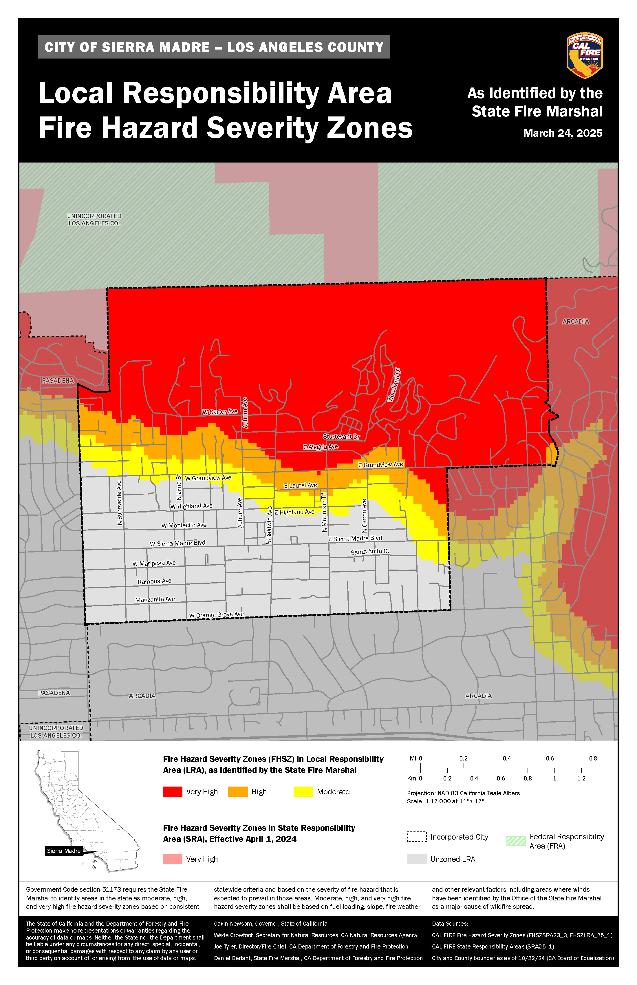
2025 Fire Hazard Severity Zone Map Update
On March 24, 2025, CAL FIRE released updated Fire Hazard Severity Zone (FHSZ) maps for Los Angeles County—the first major update in over 10 years. These maps added 3.5 million acres of designated hazard zones across Southern California, including a 30% increase in areas classified as Very High fire hazard.
The updated maps now apply to Local Responsibility Areas (LRAs), which include Sierra Madre, and reflect changes to the city’s fire hazard classifications. Using the latest data on climate, fire history, terrain, and wildfire behavior, these maps provide a more accurate picture of long-term wildfire risk.
Previously, only Very High hazard areas were mapped in LRAs. However, due to new state legislation—Senate Bill 63 (SB 63)—the updated maps are now required to include High and Moderate zones as well, significantly expanding the scope of fire hazard planning and safety requirements.
The updated Fire Hazard Severity Zones are shown in the image below. For more information, visit osfm.fire.ca.gov/FHSZ. Residents can use the “Explore Fire Hazard Severity Zones” tool to search by address and view the current designation of their property. The online map also allows users to compare the newly updated zones with the 2011 adopted maps.

Next Steps for the City of Sierra Madre
Review the Updated FHSZ Maps Provided by CAL FIRE
- Analyze how the new Moderate, High, and Very High designations affect parcels within Sierra Madre.
- Cross-reference with current zoning, general plan, and wildfire risk areas.
Conduct Public Outreach and Accept Community Input
- Host community meetings or town halls.
- Promote the FHSZ community survey (due April 27).
- Make updated maps accessible on the City’s website and in City Hall.
- Educate the public on what the zone changes mean for homeowners, developers, and real estate.
Prepare and Adopt a Local Ordinance Within 120 Days
- Per AB 211, local jurisdictions must **adopt CAL FIRE’s designations by ordinance within 120 days of receipt.
- The ordinance can maintain CAL FIRE’s zoning or upgrade to higher designations (based on evidence), but cannot downgrade zones.
Align Local Codes and Plans with FHSZ Designations
- Update the General Plan Safety Element, zoning ordinances, and building code requirements (e.g., Chapter 7A for WUI areas).
- Implement defensible space enforcement and hazard disclosure requirements.
Coordinate with Fire Department and Emergency Services
- Update evacuation routes, emergency response plans, and mitigation strategies.
- Ensure essential facilities are not placed in high hazard zones “when feasible” (per state law).
Document Compliance and Planning for Grant Opportunities
- Ensure all updates and community engagement efforts are documented.
- Maintain eligibility for state and federal hazard mitigation funding.
What does this mean for the City of Sierra Madre?
For Sierra Madre residents, the updated Fire Hazard Severity Zone (FHSZ) maps may affect multiple aspects of homeownership, insurance, and overall wildfire preparedness. Properties located within newly designated High or Very High hazard zones may now be subject to stricter building code enforcement, particularly under California’s Wildland-Urban Interface (WUI) regulations.
Additionally, homes in Very High zones are required to maintain at least 100 feet of defensible space around structures—a requirement that is enforced locally and may involve periodic inspections or citations for non-compliance. Sellers are also legally obligated to disclose a property’s fire hazard classification in real estate transactions, which can influence buyer decisions and resale value. Learn more about Defensible Space and Home Hardening.
While CAL FIRE’s maps are not used directly by insurers to calculate wildfire risk, many insurance companies reference similar data or fire zone classifications when determining coverage eligibility or premiums. As a result, some homeowners in High or Very High zones may face higher insurance rates, stricter policy terms, or may be referred to the California FAIR Plan for limited fire coverage. Insurance F&Q
These updated maps also guide the City’s evacuation planning, zoning decisions, and grant eligibility for hazard mitigation efforts. Public awareness and participation will continue to play a vital role in building a more fire-resilient Sierra Madre.
To ensure local voices are heard, the City is launching a short community survey to gather input on the update, wildfire concerns, and the types of resources needed to support preparedness.
Take the survey here:
https://www.surveymonkey.com/r/KNPPQDQ